


Right around the start of the Atlantic hurricane season each year we hear about ENSO – short for the El Niño Southern Oscillation – a term used to describe fluctuations in the temperature of the tropical Pacific.
We hear about ENSO because it has a robust influence on the ability of Atlantic hurricanes to develop and intensify. In many ways, the known connection between ENSO and Atlantic tropical cyclones (TCs) is remarkable given their centers of action are over 7,000 miles apart.
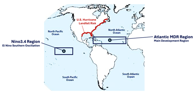
In the Atlantic, warmer sea-surface temperatures (SSTs) mean more fuel for hurricanes to reach their full potential. In the Atlantic, the area where hurricanes are most likely to form is called the “Main Development Region” or MDR. In the Pacific, the area where changes in SSTs fluctuate between warm (known as El Niño) and cool (known as La Niña) is called the Nino3.4 region.
The Mystery of Global Teleconnections
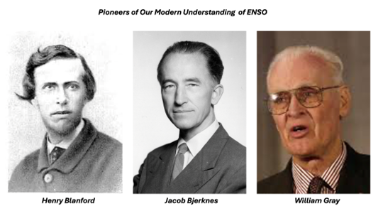
Despite a vast separation on the globe, physical connection between climatic regions was first uncovered in the 1880s when Henry Blanford – a pioneering British meteorologist – noticed that when air pressure rose in India it simultaneously rose in Asia and Australia. About ten years later near the turn of the century, other scientists reinforced the notion by observing drought conditions in India also coincided with drought in Australia.
Connections between the Atlantic and Pacific related to what we now call ENSO were first hypothesized in the 1920s and 1930s. This is when the term “teleconnection” was first coined, with the prefix “tele” denoting the long-distance aspect of the link. It wasn’t until 1969 when Norwegian-American meteorologist Jacob Bjerknes1 published a groundbreaking study that proved El Niño (periodic warming of the Pacific) and the Southern Oscillation (coinciding changes in atmospheric pressure) were in fact two parts of a coupled global mechanism. The relationship between them became the term we use today to describe a single climate feature – ENSO.
From there, scientists extrapolated the idea to other climate mechanisms and other parts of the world. In 1984, Dr. William Gray of Colorado State University (CSU) – the founder of modern-day seasonal hurricane prediction – published research that first connected El Niño to Atlantic hurricanes. His research proved that during El Niño years the unusually warm Pacific caused intense warming in the atmosphere, dramatically altering the global circulation. The result is a stream of anomalous westerly winds high above the surface over the Caribbean and tropical Atlantic.
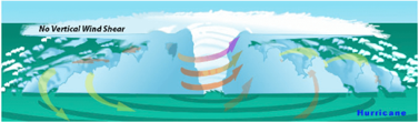
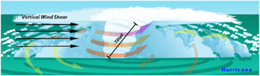
Because surface winds in the Atlantic naturally blow from the east, these westerly winds aloft create a massive layer of “vertical wind shear” – defined as the change in winds with height – which has a major inhibiting effect on hurricane structure and intensification. Dr. Gray theorized that this elevated shear physically disrupts the fragile vertical core of a developing hurricane, cutting off its ability to draw energy from the warm ocean, thereby preventing intensification.
What is a “Super El Niño”?
Once the importance of ENSO became established as a scientific principal, meteorologists wondered just how warm this region of the Pacific could get, and more importantly, what can we say about these climate extremes? SST anomalies are measured as a deviation from the long-term average to define how warm an El Niño is relative to normal or “neutral” ENSO conditions.
When anomalies are less than a half-degree Celsius warmer than average, ENSO is characterized as “warm-neutral” and not an official El Niño. If anomalies exceed 0.5 deg C but remain under 1.0 deg C, it is defined as a “Weak El Niño” event. The progression up in warmth from a Weak to Moderate to Strong El Niño describes the vast majority of ENSO warm cycles.
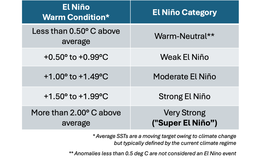
Only when ENSO anomalies are in their most extreme climate mode – exceeding +2.0 deg C above average – do meteorologists officially declare a Very Strong El Niño, or as the press has dubbed it a “Super El Niño”. Similar anomaly categories are applied to La Niña conditions.
Looking back over the modern “warm Atlantic period” since 1995, the ENSO state during the most active months of hurricane season has been in the warm ENSO mode 8 out of 31 years, or in other words, returns on average about once every 3 to 5 years. Most seasons are ENSO-neutral, and some are in the cool mode, also known as La Niña.
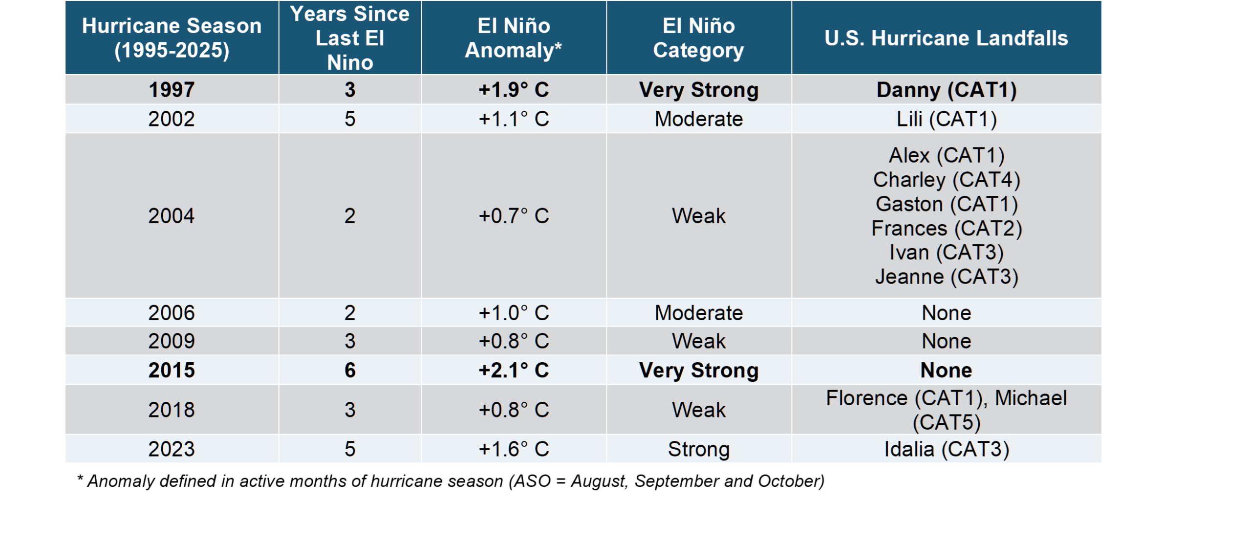
As the table shows, there have only been two Very Strong (“Super”) El Niño events over this period, implying a long return period of about 20 years, a truly ‘extreme’ ENSO event. Those hurricane seasons – 1997 and 2015 – were characterized by low basin activity and minimal landfall risk, since only Danny in 1997 made U.S. landfall as a marginal CAT1 hurricane.
But as we widen out to more common El Niño seasons, such as 2023 which observed a strong El Niño, there was significant landfall risk in the form of the major landfall of Idalia at CAT3 strength. Looking farther back to 2004 which had a weak albeit official El Nino event, there were six U.S. landfalls – of which three were majors and three struck Florida. In fact, the 2004 season still holds the record today (tied with 2020) for the most U.S. hurricane strikes in a single season.
This broader picture of El Niño and its effects on the Atlantic are an important reminder that even in El Niño years where wind shear reduces ‘climatological’ risk of hurricanes, the volatility of everyday weather can overcome those impediments and produce intense storms and catastrophic losses. To advance our understanding of these complexities, Aeolus Research is building specialized models that relate climate factors such as ENSO that modulate the season overall to weather factors such as steering and rapid intensification that influence individual storms and the risks they impose in real-time (https://aeolus.com/aeolus-and-cornell-university-announce-research-collaboration-focused-on-hurricane-track-modeling/).
What about ENSO in other parts of the world?
ENSO’s warm mode of El Niño is not just important for Atlantic hurricane risk, it also affects tropical cyclones in other parts of the world as well as other weather events occurring at other times of year.
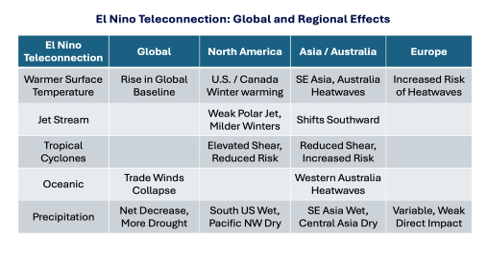
The massive amount of heat contained in the Pacific region during a moderate to strong El Niño can have direct effects on global temperatures. The effect is also felt regionally, with U.S., Canada, SE Asia and Australia all observing warmer temperatures and increased risk of heatwave and drought. Despite being a half-a-globe away from the ENSO signal, even Europe tends to experience more heat waves. Western Australia also experiences more heatwaves since the effect is amplified by the oceanic effects of El Niño on ocean currents and trade winds local to the region.
Because of the profound effects of ENSO on moisture distribution via the ocean-atmosphere interactions mentioned earlier, there is a physical change to waves that form along the belt of upper-level winds that guides and fuels extra-tropical cyclones (“winter storms”) which themselves can cause catastrophic loss in the Pacific NW U.S., Canada and parts of the U.S. East Coast. The effects of El Niño on European winter windstorms are typically less direct, though some research shows it may have a tempering effect on the risk.
Regarding the effect of El Niño on TCs outside the Atlantic, the condition has the opposite effect on wind shear south of the equator, allowing for more TCs to develop and intensify, thereby increasing the risk of landfall and catastrophic loss. This includes the volatile and densely populated region of Southeast Asia where typhoons (a.k.a. “SE Asian hurricanes”) can strike China, Taiwan, Hong Kong, the Philippines and adjoining areas.
While the effect of El Niño on the global distribution of clouds and precipitation is profound, it is the local effects that matter most. The Southern U.S. and SE Asia regions experience more extra-tropical cloudiness, major downpours and flooding. In contrast, the Pacific NW and Central Asia tend to experience fewer storms, less cloudiness and dry conditions, which in their extreme can lead to extended drought.
These conditions can also have significant impacts away from direct physical risks, including effects on ecosystems, agriculture and public health. This is due to the widespread and potentially profound impacts of any significant ENSO event – be it El Niño or La Niña (https://aeolus.com/aeolus-insight-report-understanding-enso/). ENSO has cemented its position as one of the most important climate cycles known to science.
Some Takeaways
ENSO and its warm mode of El Niño get a lot of attention, mainly due to known physical effects on Atlantic hurricanes. However, ENSO is a massive ocean-atmosphere phenomenon that remotely affects both global climate and regional risks. These “teleconnections” are profound and merit hundreds of scientific studies around those effects and ultimately how predictable they may be.
ENSO – like all climate signals – is changing as the climate changes, so we must remain diligent in our understanding of the phenomenon when evaluating risk in the near-present climate. Aeolus Research continues to consider detailed analyses – including historical observation and modeled hurricane seasons – to further advance our understanding in collaboration with the academic and scientific community.
As Aeolus continues to push the boundaries of research through these studies and collaborations, our focus is starting to move from the analysis phase and towards implementation. We are excited and look forward to incorporating the most robust research results into our portfolio management decisions and, ultimately, enhancing returns for our investors.
1Jacob Bjerknes’ father was Vilhelm Bjerknes, a celebrated Norwegian physicist and meteorologist who is widely considered one of the pioneers of modern weather forecasting.
DISCLAIMER
THE THE INFORMATION CONTAINED IN THIS PAPER (THE “INFORMATION”) IS BEING FURNISHED TO RECIPIENTS ON A CONFIDENTIAL BASIS BY AEOLUS CAPITAL MANAGEMENT LTD. (“AEOLUS”) FOR DISCUSSION PURPOSES ONLY AND MAY NOT BE USED FOR ANY OTHER PURPOSE. THIS INFORMATION MAY NOT BE COPIED, RECORDED OR REPRODUCED OR OTHERWISE PROVIDED TO THIRD PARTIES IN WHOLE OR IN PART WITHOUT AEOLUS’ PRIOR WRITTEN CONSENT.
THIS PAPER CONTAINS INFORMATION REGARDING AEOLUS AND ITS AFFILIATES’ VIEWS ON VARIOUS UNCERTAIN SCIENTIFIC CONCEPTS AND CONTENT. RECIPIENTS AND THEIR ADVISORS SHOULD PERFORM THEIR OWN INDEPENDENT REVIEW WITH RESPECT TO SUCH MATTERS AND REACH THEIR OWN INDEPENDENT CONCLUSIONS.
WHILE EFFORT AND CARE HAS BEEN TAKEN IN PREPARING THE CONTENT OF THIS PAPER, AEOLUS AND THE AUTHORS DISCLAIM ALL WARRANTIES, EXPRESSED OR IMPLIED, AS TO THE ACCURACY OF THE INFORMATION SET OUT HEREIN. FURTHER, NEITHER AEOLUS NOR THE AUTHORS SHALL BE LIABLE FOR ANY LOSSES OR DAMAGES ARISING FROM THE USE OF, OR RELIANCE ON THE INFORMATION OR THE REFERENCES SET OUT HEREIN.
PORTIONS OF THE INFORMATION HAVE BEEN OBTAINED FROM THIRD PARTY SOURCES. WHILE SUCH INFORMATION IS BELIEVED TO BE RELIABLE BY AEOLUS AND THE AUTHORS, NO EXPRESS OR IMPLIED WARRANTY, REPRESENTATION OR GUARANTEE IS MADE AS TO THE CORRECTNESS, COMPLETENESS OR SUFFICIENCY OF SUCH THIRD PARTY INFORMATION. WHERE A THIRD PARTY RESOURCE HAS BEEN REFERENCED, AEOLUS SEEKS TO ACCURATELY CITE SUCH RESOURCE. NO CONTENT WITHIN THIS PAPER IS KNOWINGLY AN INFRINGEMENT OF COPYRIGHT. ANY POTENTIAL INFRINGEMENT CAN BE IMMEDIATELY ADDRESSED AND WHERE APPROPRIATE RECTIFIED, ON NOTIFICATION TO AEOLUS.
THIS PAPER CONTAINS THE CURRENT OPINIONS OF AEOLUS AND SUCH OPINIONS ARE SUBJECT TO CHANGE WITHOUT NOTICE. AEOLUS TAKES NO RESPONSIBILITY FOR UPDATING THE INFORMATION CONTAINED HEREIN AS FACTS OR AEOLUS’ VIEWS DEVELOP IN FUTURE. STATEMENTS IN THIS PAPER ARE MADE AS OF THE DATE OF THE INITIAL COMMUNICATION AND THERE SHALL BE NO IMPLICATION THAT THE INFORMATION IS CORRECT AS OF ANY TIME SUBSEQUENT TO SUCH DATE.
THE INFORMATION CONTAINED IN THIS PAPER IS NON-PUBLIC, CONFIDENTIAL AND PROPRIETARY IN NATURE. BY YOUR ACCEPTANCE OF THIS PAPER, YOU AGREE TO TREAT THE CONTENTS AS CONFIDENTIAL AND NOT TO USE IT IN ANY WAY DIRECTLY OR INDIRECTLY DETRIMENTAL TO AEOLUS.